Point Groups Manager
The points are organized in groups to allow an easy differentiation of these. A FlashPoints group is a list containing a number of point numbers on which it is possible to perform various operations (rotation, altitude change ...).
Point groups are managed through the "Point Group Manager" dialog box.
The Manager allows you to create or delete groups of points, to add or remove points from a group of points by selection or criteria, to consult the list of points, etc.

Import a coordinate file
FlashPoints allows you to create points in the current group from a text or Leica (.gsi) coordinate file.
A columnar text coordinate file must have the following structure :
The fields can appear in any order and the field separator can be a Space, a Comma or a Semicolon. You must indicate the position of the fields in the file.
A Leica GSI coordinate file can be GSI8 or GSI16.
The points will be created based on size, color, etc. settings that you specified in the 'Settings' tab of the dialog box.

Points, numbers and altitudes

Attributes Non-overlapping

Frame around Attributes
FlashPoints includes all the tools to organize, modify, edit your points, among which:
Points
Attributes
Filter entities

Points Number input box

Auto drawn polylines and multi-copied circle
FlashPoints comes with a "Points Number input box" that lets you respond to AutoCAD commands with a point Number or a sequence of points Numbers rather than with a click or coordinates.
This dialog box activates whenever you pass the mouse cursor over it.
You can for example issue the POLYLINE command, then enter in the box "100-200,205,207" : this will create a polyline passing through points 100 to 200, then 205, then 207
Other example : multiple copy of entities: issue the COPY command, select objects to be copied, select the "Multiple" option of the command, indicate the base point, then put the mouse cursor on the "FlashPoints" input box. It activates, enter " 100-125" in the edit-box, then [RETURN], the selected objects are copied at points 100 to 125.
If you enter a point number in the box while there is no active command, the point number and its coordinates will be shown on the command line as follow : >> Coordinates of point 125 : X=906.124, Y=519.413, Z=10.000
get_app |
Download FlashPoints 3.03 |
| Download demo version, fully functional but limited to 20 days | |
Available for AutoCAD, BricsCAD, ZWCad and GStarCAD |
|
shopping_cart |
Buy FlashPoints 3.03 - 65.00 € TTC |
| Get a license on the secure payment site Paypal | |
Enter the serial number of the software, then click 'Pay now'. You will be redirected to Paypal.com website to register. You'll then receive your license code by e-mail within minutes. (Make sure your anti-spam filter doesn't block messages from DeliCAD.com). |
|
info |
Additional Information |
| Help - More information | |
You want more information on this application or on the site, on the means of payment or the purchase of several licenses, do not hesitate to contact me. |
|
![]()
![]()
(C) DeliCAD.com - Add-ons for AutoCAD, BricsCAD, ZwCAD in topography, architecture, mechanics
Entreprise Individuelle Philippe Sérange
21 rue du Batifois
63500 Issoire - Puy-De-Dôme (63)
RCS Clermont-Ferrand 478 467 814
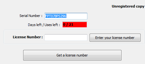
To find your serial number, click the 'Help' button (![]() ) of the add-on toolbar.
) of the add-on toolbar.
A dialog box displays, showing this number (in blue) :