Flashpoints for AutoCAD and BricsCAD allows the import and management of points, topographic or other.
FlashTalus for AutoCAD and BricsCAD allows the creation of dynamic 2D slopes (reacting to the modification of the elements composing them).
FlashCadre allows you to create a grid.
DivSurf lets you divide an irregular polygon composed of lines and / or arc segments into sub-polygons with a predefined surface.
FlashMNT is a tool for creating a digital terrain model, and 3D modeling.
Longitudinal and cross sections, calculation of cubatures.
FlashPolygons creates closed polylines from a selection of polylines.
RapidDXF LT allows to convert coordinates files.
DXF Works allows to extract coordinates and other various data from DXF files.
![]()
![]()
(C) DeliCAD.com - Add-ons for AutoCAD, BricsCAD, ZwCAD in topography, architecture, mechanics
Entreprise Individuelle Philippe Sérange
21 rue du Batifois
63500 Issoire - Puy-De-Dôme (63)
RCS Clermont-Ferrand 478 467 814
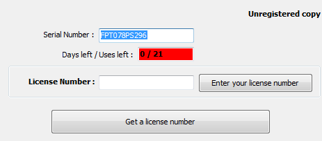
To find your serial number, click the 'Help' button (![]() ) of the add-on toolbar.
) of the add-on toolbar.
A dialog box displays, showing this number (in blue) :